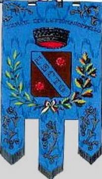
from <www.geocities.com>, located by Jarig Bakker , 18 March 2000

Last modified: 2004-12-22 by dov gutterman
Keywords: abruzzi | pescara | lettomanoppello |
Links: FOTW homepage |
search |
disclaimer and copyright |
write us |
mirrors

from <www.geocities.com>,
located by Jarig Bakker , 18 March 2000
See also:
From <www.geocities.com>:
Not far from the Adriatic coast, about 21 miles west of the city
of Pescara, is the town of Lettomanoppello, known in the local
dialect as Lu Lette. The town's population is about
3000.
Situated on the east bank of the now dry Lavino River,
Lettomanoppello is located at the edge of the Majella National
Park, on the lower slopes of Blockhaus, one of the Majella
mountains, at an elevation of 1200 feet. A road through the
town continues up Blockhaus, almost to the top, an elevation of
7000 feet. From this vantage point, there are beautiful
views into the Majella and into the broad Pescara Valley below.
The first records of Lettomanoppello date back to the 11th
century. However, the town was occupied centuries earlier, and
was renowned in Roman times for its asphalt mines. The
Romans established a colony of African and Asian slaves at
Lettomanoppello. The slaves worked the asphalt mines, and the
asphalt was transported to the Adriatic Coast on the Aterno River
or carried on the backs of animals to Rome. In 1868 a piece
of bitumen (the rock from which asphalt is extracted) was
discovered near the Valle Pignatara section of Lettomanoppello;
the rock is inscribed in Latin with the name of the owner or
o