This page is part of © FOTW Flags Of The World website
Hoogezand-Sappemeer (The Netherlands)
Groningen province
Last modified: 2005-04-23 by jarig bakker
Keywords: hoogezand-sappemeer |
Links: FOTW homepage |
search |
disclaimer and copyright |
write us |
mirrors
 Shipmate Flagchart : http://www.shipmate.nl/flags.htm
adopted 19 October 1956
See also:
Hoogezand-Sappemeer municipality
Number of inhabitants (1 Jan 2003): 33.658; area: 73,05 km². Settlements:
Hoogezand (seat), Achterdiep, Borgercompagnie (ged), Borgweg, Foxham, Foxhol,
Foxholsterbosch, Jagerswijk, Kalkwijk, Kiel-Windeweer, Kleinemeer, Kropswolde,
Lula, Martenshoek, Meerwijck, Nieuwe Compagnie, Sappemeer, Tripscompagnie
(ged), Waterhuizen, Westerbroek, Wolfsbarge
Hoogezand and Sappemeer merged on April 1, 1949, being in fact one
long village along the 'Winschoterdiep', the canal from Groningen city
to Winschoten. This was part of the big moorland region of East Groningen/Drenthe,
where peat was dug. After that it became an industrial region, where shipbuilding
is the main feature.
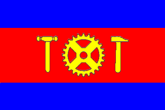
The flag was adopted 19 October 1956. The BRB refers to the old flag
of Sappemeer, still in use by the Zeemanscollege in
that place. The tools (a riveting-hammer, a cog-wheel and a carpenter's
hammer) refer to the industrial aspect of the c Shipmate Flagchart : http://www.shipmate.nl/flags.htm

 Shipmate Flagchart : http://www.shipmate.nl/flags.htm