
Last modified: 2004-12-18 by dov gutterman
Keywords: chernivtsi | chernovicy | khotyn | hotin | fortress | tower | crescent | sabre | cross |
Links: FOTW homepage |
search |
disclaimer and copyright |
write us |
mirrors
 (1:1)
(1:1)
by Ivan Sarajcic, 23 January 2000
See also:
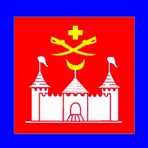
Hotin is Ukrainian town in Bessarabia which adopted armorial
achievement and banner. The Author is Vladimir Denisov according
to "Znak" - Paper of the Ukrainian Heraldry Society .
Ivan Sarajcic, 23 January 2000
Unless I'm completely wrong, Bessarabia (aka Dobrudja?) is in
the Danube delta, while Chernivtsi lies much to the north, in the
Carpathian mountains, near the meeting point of Hungary, Poland,
Slovakia, Moldavia, Rumania and Ukraine...
Antonio Martins, 25 January 2000
The Danish encyclopaedia says (in part): "Area by the
Black Sea [not really] between the rivers Prut and Dniestr
[exactly], approx 45000 km2."
"... with the military defeat in 1945, Bessarabia was once
more assigned to the Soviet union. Administratively, the
northernmost and the two southernmost provinces were added to the
Ukraine, while the larger and central part of Bessarabia was the
core of the Moldavian SSR, ..."
I found Khotin in my Bordas Atlas Geographique. It is on the
upper Dniestr.
So, no. Bessarbia is not Dobrudja. Dobrudja is south of the
Danube.
Ole Andersen , 25 January 2000
And that's exactly where Hotin also lies. It was spot of heavy
Ottoman-Polish fights in 17th and 18th century. Search for Hotin
north - northwest of northernmost Roumanian border.
Velid Jerlagic, 25 January 2000
Khotyn or Khotin or Hotin is part of Chernivtsi oblast. It is
northeast of the Bukovina region and northwest (but not part of)
Bessarabia.
'Town, southwest Ukraine, on right bank of the Dniestr, 48 km
northeast of Chernovtsy; pop. (1959) 10,319; formerly in
Bessarabia; a former military post at a much-used crossing of the
Dniestr. In medieval times a Genoese colony (so it should have a
gonfalone, no?); belonged successively to Moldavians, Poles,
Russians, Turks and Romanians; scene of Turkish defeat 1621 by
Poles inder Chodkiewicz and Stanislaw Lubomirski and again in
1673 by John III Sobieski; seized by Russia 1739 and with
Bessarabia incorporated in Russian Empire 1812; under Romania
1918-40; held by Germans 1941-44. (source: Webster's New
Geographical Dictionary, 1988)
Jarig Bakker, 25 January 2000
From Ukrainian
Heraldry web site :
"In March 21 1996 the session of the town council approved
the gonfalon: a rectangular canvas with a ratio of the sides:
1:1. In a red field there is an image of white fortress with two
towers with bunchuks above it, above a fortress there are two
crosslike white sabers with a yellow cross ab