 (2:3)
(2:3)by Raul Orta, 3 October 2003

Last modified: 2004-08-07 by dov gutterman
Keywords: amazonas | venezuela |
Links: FOTW homepage |
search |
disclaimer and copyright |
write us |
mirrors
 (2:3)
(2:3)
by Raul Orta, 3 October 2003
See also:
Municipalities (Capitals):
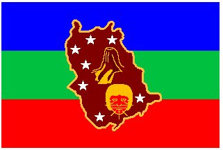
Here is information about the new flag of Amazonas State:
Antecedents - Amazonas State, second in extension of the
Republic, is located on the South end of Venezuela and limits
with Bolívar State to the North; Federative Republic of Brazil
to the South and East and Republic of Colombia to the West. It
receives its name on April 23rd ,1856 in honor to the world wide
mighty river discovered by Conqueror Francisco de Orellana on
1542, who too baptize it with the Greek voice which identifies
the legend about a race of warrior women which lived on the
Asiatic region of Sarmatia, located far along the Caucasus.
Elevated to the category of State by Special Law No. 35015 dated
on July 19th, 1992, in force since December 31st that year,
it has as capital the city of Puerto Ayacucho, founded on
December 9th,1924 by Engineer Santiago Aguerrevere executing
orders of the Presidency of the Republic. It's integrated by the
municipalities Alto Orinoco, Atabapo, Atures, Autana, Guainía,
Manapiare and Río Negro.
Sources: Web Site Aldea Educativa <www.aldeaeducativa.com>.
Material provided by the Direction of Public Affairs of Amazonas
State Government, October 2003
The Flag - Attributes and Semio