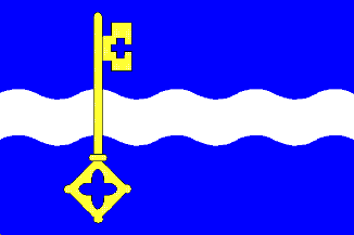
This page is part of © FOTW Flags Of The World website
De Marne (The Netherlands)
Groningen province
Last modified: 2004-09-24 by jarig bakker
Keywords: de marne |
Links: FOTW homepage |
search |
disclaimer and copyright |
write us |
mirrors
 Gerard van der Vaart - Shipmate : http://www.shipmate.nl/flags.htm
adopted 26 Feb 1991
Other De Marne pages:
See also:
De Marne municipality
Number of inhabitants (1 Jan 2003): 11.180; area: 167,35 km². Settlements:
Leens (seat), Broek, Eenrum, Hornhuizen,
Houwerzijl, Kleine Huisjes, Kloosterburen, Kruisweg, Lauwersoog, Mensingeweer,
Molenrij, Niekerk, Pieterburen, Schouwerzijl, Ulrum,
Vierhuizen, Warfhuizen, Wehe-den Hoorn, Westernieland, Zoutkamp, Zuurdijk
De Marne is a new municipality in northwest Groningen, consisting of
the old municipalities of Ulrum, Leens, Kloosterburen and Eenrum
(since 1 Jan 1990; the municipality was first named Ulrum; on 1 Jan 1992
it was renamed De Marne). It is an agricultural area with the old harbor
of Zoutkamp on the spot where the canalized river 'Reitdiep' streamed into
the Lauwerszee; and of course with the creche for seals in Pieterburen.
Info from <http://www.bng.nl/ngw/m/demarne.htm>:
This area was formerly an island in the Hunze river. Named 'De Marne'
it was a division of the region Hunsingo. De Marne enjoyed legal freedom
as the Ger Gerard van der Vaart - Shipmate : http://www.shipmate.nl/flags.htm

 Gerard van der Vaart - Shipmate : http://www.shipmate.nl/flags.htm